In the face of more frequent flooding events, many wonder: how long can Nantucket continue to tread water?
Former Nantucket Fire Chief Bruce Watts remembers piloting a rescue boat during the NoName storm on October 30, 1991 in the Brant Point area when he hit something unexpected. “We heard a clunk, and the motor swung up, and I looked…and there was a Volkswagen that we hit with the prop,” he says. “I mean, there was at least eight feet of water [on Hulbert Ave.]” Floodwaters from what’s since become known as the Perfect Storm drowned the Brant Point neighborhood between Galley Beach and Easton Street and from The Cliff to the harbor channel. Flooding of a magnitude that devastating hadn’t been seen again—until this winter.
 Winter storms Grayson and Riley have wrested Nantucket back to the ominous reality of being ground zero for sea level rise. “[Riley] was the storm that had the most significant flooding that I’ve personally seen,” says Nantucket Natural Resources Coordinator Jeff Carlson. “I moved out here in 2000, and I wasn’t here for the No-Name Storm, but this is definitely the largest single amount of water that I’ve seen come into these areas.”
In the past, major flooding events from storms have occurred far enough apart to earn them the National Weather Service monikers of 50- or 100-year storms. However, with several nor’easters hitting in succession, this past winter is a portent that Nantucket is dangerously unprepared for sea level rise and inevitable future storms.
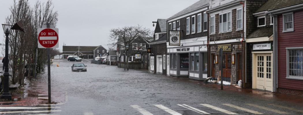
 The devastation of this winter’s storms was unmistakable. Riley flooded the Brant Point area and the downtown blocks with several feet of water. The storm pulverized the floating docks of the town pier, undermined Polpis Road near Sesachacha Pond, submerged finger piers and boat basin docks, and engulfed Straight Wharf and the nearby Stop & Shop parking lot. Meanwhile, Grayson’s arrival coincided with single-digit temperatures that, combined with flooding, ruptured downtown sewer lines, forcing the town to discharge 2.7 million gallons of sewage into the harbor.
“I think it’s very eye-opening to people to see just how vulnerable some of these resources are and how important this is to really pick up the pace and figure out how to better protect our infrastructure,” says Carlson. Practical solutions are in the works. Already, some of the outfall pipes emptying into the harbor are fitted with outgoing, one-way only “duck bill” valves. In 2017, the town refortified the Easy Street Basin bulkhead, raising it by 18 inches.
 As Nantucket’s sea-level-rise protocol evolves, the island may want to look to the sophisticated strategies employed in the Netherlands—where much of the country is near or below sea level—such as “controlled flooding.” Using a combination of dams, barriers, sluices and flood overflow containment areas, the Netherlands has learned to live with sea level rise.
Unfortunately, there’s no cheap or easy solution for Nantucket to adopt from the Netherlands, says Ambassador Timothy Broas, a Nantucket summer resident who served as ambassador to the Netherlands under the Obama Administration and who worked on the frontlines of Dutch climate change efforts.
“The Dutch government has invested tens of billions of Euros into its water management programs,” he explains. “The country deploys a sophisticated system of dikes, dunes, dams and mechanized surge barriers to resist and control the coastal rising sea levels.” With almost two-thirds of the Netherlands below sea level, Broas explains, the government regularly reclaims significant portions of land from the sea in order to redirect threatening levels of water and develop new landmasses, known as polders. “A nationwide system of managed canals operates to control and measure outgoing and incoming water. Many of the Dutch provinces also flood designated parts of the country as a measure of control and flood plain maintenance, and to assist with agricultural and salinization demands.”
 Implementing similar approaches on Nantucket would require a complete reworking of the town’s infrastructure. For now, the town’s Hazard Mitigation and Coastal Resiliency plans are discussed in terms of smart development, storm water system upgrades, flood storage capacity, forced sewer main relocation, bio-retention systems, best management practices and flood elevation construction. According to Carlson, these measures will have a long-term cost running into the millions of dollars because of needed upgrades to decades-old infrastructure, development of flood-centric design standards and employing new safeguards.
The Hazard Mitigation and Coastal Resiliency plans will help prepare for and protect the island from future storm events, while giving it the tools to quickly rebound and rebuild after the carnage.
“The town is understanding that these storms are not going to get less frequent and sea level is definitely coming up, so as we are upgrading, working on all these projects together, instead of planning for the next 10 years, we need to be planning for further out knowing that in 50 years, the sea is not going to be at the same level that it is today,” says Carlson.
At the homeowner’s level, the rising sea level and flooding trends has given rise to new businesses on the island dedicated to protecting people’s properties. This April, John Kitchener sent out 350 direct mail pieces to a cross section of island homes that are at risk of flooding. A former senior executive at Avon cosmetics, Kitchener moved to the island full-time in 2006 and is now launching Nantucket Property Watch, LLC, a caretaking operation that will deploy sophisticated monitoring technology in his clients’ homes to thwart destruction from future storms and flooding. “People who have never had water in their basement are getting water in their basement,” he explains. “And it’s not flowing down from above; the water is coming up from ground.”
 For $4,000 to $6,000 a year, Kitchener’s Nantucket-based team will not only monitor a property through digital devices and weekly visits, but they will create contingency plans for when disaster strikes. “We’re going to have our own inventory of generators, pumps and all the equipment you need to resolve the situation quickly,” he says. “This is our only business: looking after people’s homes twenty-four hours a day, seven days a week.”
Steamboat Wharf’s tide gauge data reveals long-term average sea level rise around Nantucket is 3.6 millimeters annually. From 1965 to 1999, it averaged 2.91mm and it doubled between 2000 to 2017 to 6.84mm. And the Intergovernmental Panel on Climate Change (IPCC) predicts the Northeast is likely to experience more rapid sea level rise than much of the coastal areas on our planet predominantly due to a “weakening Gulf Stream.” The current IPCC global sea level forecast is roughly three to 10 feet higher than present by 2100.
A locally popular estimate puts Nantucket on track to disappear in around 400 years, but Graham Giese, director of the Land & Sea Interaction Program at the Center for Coastal Studies in Provincetown, Massachusetts has Nantucket losing six acres of upland annually to sea level rise. At roughly 30,000 acres and 112 feet above sea level, without factoring in the almost certain increasing rate of sea level rise and erosion, Nantucket could hang around for much longer.